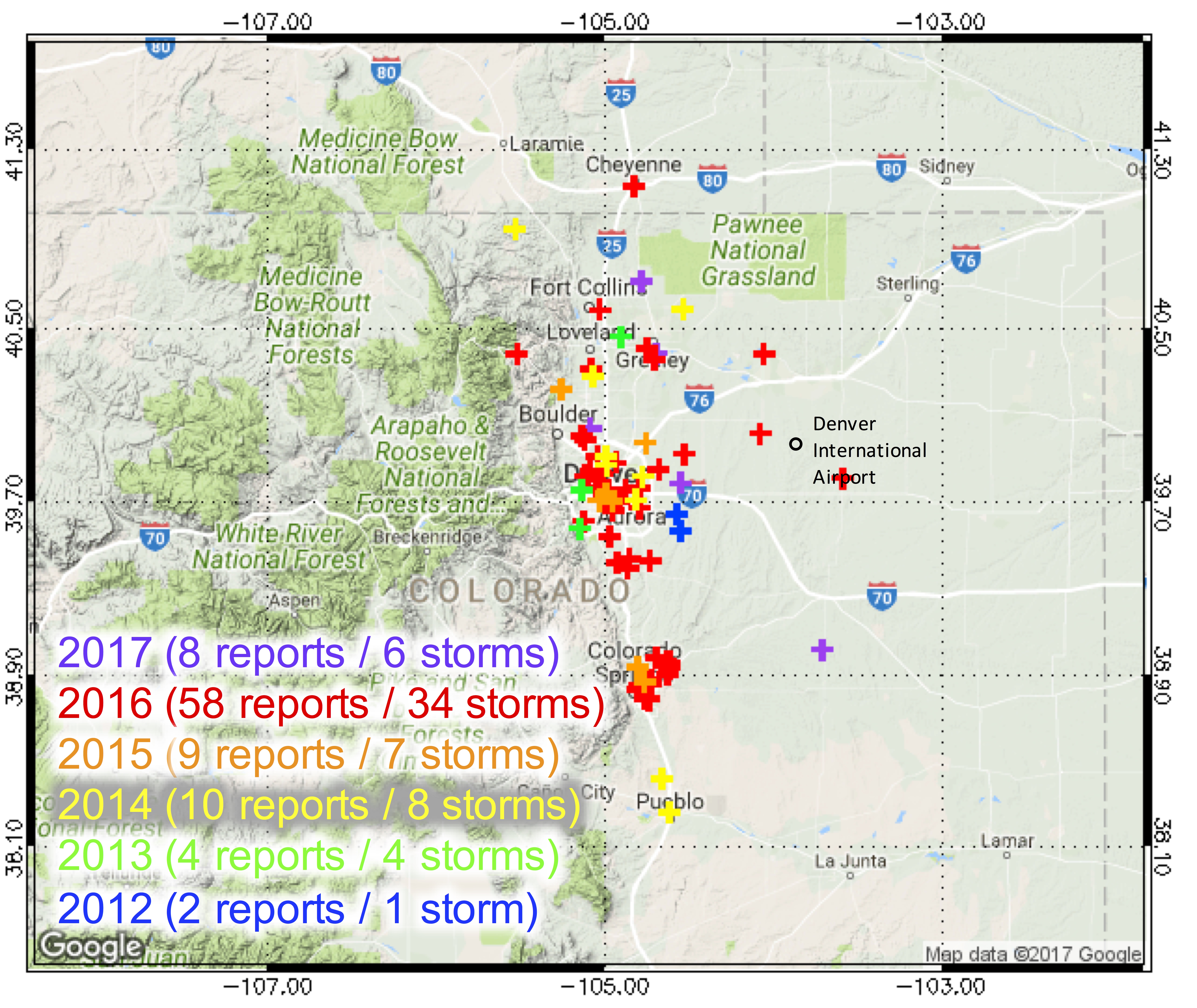
 Fig. 2: Hail report archive along the Colorado Front Range since 2012.
By the end of the 2016 thunderstorm season, we had received over 44 reports in Colorado alone with the detailed information requested (Fig. 2). Can you find your report? We added 26 more reports from years 2012 through 2015 that were obtained from the Community Collaborative Rain, Hail and Snow (CoCoRaHS) network, the NWS, newspapers, and television stations. Most of the 70 total storms occurred along the Colorado Front Range between 2012–2016, and all data from them are archived.
Fig. 2: Hail report archive along the Colorado Front Range since 2012.
By the end of the 2016 thunderstorm season, we had received over 44 reports in Colorado alone with the detailed information requested (Fig. 2). Can you find your report? We added 26 more reports from years 2012 through 2015 that were obtained from the Community Collaborative Rain, Hail and Snow (CoCoRaHS) network, the NWS, newspapers, and television stations. Most of the 70 total storms occurred along the Colorado Front Range between 2012–2016, and all data from them are archived.
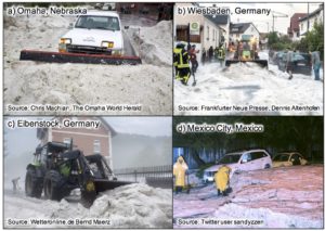
Recent and Historic Accounts of Hail Accumulations: In recent years, national and international news agencies and television stations have run stories on deep hail accumulations. For instance, up to 20 cm of hail with hailstones up to 4 cm in diameter was reported in Omaha, Nebraska, on 11 May 2016 (Fig. 3a). The deep hail occurred when an isolated thunderstorm passed over Omaha at around 0800 UTC. In the wake of the storm, morning commutes were disrupted. Front-end loaders plowed clogged roadways and drains were blocked by hail, while many vehicles submerged in hail had to be dug out (Withrow 2016). Deep hail accumulations have also been reported in Germany, for instance during a series of severe thunderstorms associated with a surface cold front that moved east on 28 and 29 May 2015. In the early evening on 28 May 2016, hail 10–20 cm deep was reported in Wiesbaden, a town ~30 km west of Frankfurt (Fig. 3b). On 29 May at noon local time, a series of thunderstorms associated with the same cold front passed over Eibenstock, a town ~200 km east of Wiesbaden, again producing 10–20 cm of hail on the ground (Fig. 3c). Another vigorous storm occurred in Mexico City, Mexico on 17 August 2014 and produced up to 25 cm of hail, called by the local newspaper a historic event for this city. Many roads were flooded by hail and water and remained closed for hours (Samenow 2014; Fig. 3d).
Although most reports seemed to have emerged recently, deep hail accumulation is not just a 21st century phenomenon. Schlatter and Doesken (2010) found reports of deep hail accumulations from a thunderstorm dating back to 11 July 1877 in Watertown, New York. They also described a phenomenal event with up to 45 cm of hail on level ground across a 15 x 10 km2 area on 3 June 1959 in Seldon, Kansas. The hail was so deep that several roofs collapsed and the highway had to be closed for four hours. Schlatter and Doesken (2010) discussed another event with hail up to 5 cm in diameter, accumulating to a depth of 30 cm, in Cheyenne, Wyoming, on 1 August 1985. Hail was accompanied by heavy rain with rainfall rates of 90 mm per hour (Chappell and Rodgers 1988).