Received funding from the Joint Fire Science Program to evaluate thunderstorm outflow boundaries in WRF-Fire

Received funding from the Joint Fire Science Program to evaluate thunderstorm outflow boundaries in WRF-Fire
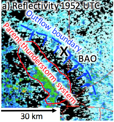
May 2017: Strong and variable winds in thunderstorm outflow boundaries interact with wildland fires, often spreading flames faster to threaten firefighter safety and amplify economical destruction. These boundaries are difficult to detect in complex terrain with operational observing networks, so reliable forecasting is required to protect life and property. One such forecast model, the Weather and Research Forecasting model coupled with a wildland fire-behavior module (WRF-Fire), has exhibited some skill in accurately predicting thunderstorm outflow boundaries in complex terrain, but rigorous validation still needs to be established before WRF-Fire can be relied upon in wildland fires. The overarching goal of the proposed research is the validation of the WRF-Fire model’s capability to accurately predict the development, movement, and magnitude of thunderstorm outflow boundaries in complex and flat terrain and during wildland fire conditions. The research will combine state-of-the-art numerical modeling using WRF-Fire, currently used by the fire weather community, with operational and state-of-the art observational tools. The proposed research will quantify model skills and uncertainties as a function of atmospheric conditions, terrain, and vegetation type. The research outcome will advance our knowledge and understanding of outflow boundary characteristics and their interaction with terrain, wildland fires, vegetation, and ambient atmospheric conditions and will quantify the forecasting skills of WRF-Fire for several types of thunderstorms and their outflow boundaries. _______________________________________________________________________________________________________________________________________
Getting ready for SNOWIE 2017
 November 2016: Seeded and Natural Orographic Wintertime clouds—the Idaho Experiment (SNOWIE) ia a comprehensive observational and modeling research program to address longstanding uncertainties regarding the effectiveness of orographic winter precipitation enhancement through cloud seeding. The overarching goal is to understand the natural dynamical and microphysical processes by which precipitation forms and evolves within orographic winter storms and to determine the physical processes by which cloud seeding with silver iodide (AgI), either from ground generators or aircraft, impacts the amount and spatial distribution of snow falling across a river basin. A field campaign will be conducted in the Payette Mountain between January and March 2017 in coordination with Idaho Power Company (IPC) who maintains an operational seeding program in the region. The core scientific objectives are to: (1) Evaluate the role of mesoscale and microscale dynamics and of the underlying terrain in the formation, growth, and fallout of natural ice crystals in winter storms through observations; (2) Investigate how the natural snow growth process is altered as a result of airborne AgI seeding through both observations and model simulations, and (3) Evaluate the effects of ground seeding on snowfall amount and distribution. In addressing (2) and (3), we will evaluate and improve the newly-developed cloud seeding module used in the Weather Research and Forecasting (WRF) model. Select cases will also be simulated using a bin resolving microphysics scheme to further investigate the microphysical evolution of the natural and seeded clouds.
_______________________________________________________________________________________________________________________________________
Organizing a Workshop on Reservoir Evaporation in October 2015
 September 2015: Reservoir evaporation has been perceived as a negligible component of the water cycle within the water resource infrastructure of the arid and semi-arid western United States (U.S. Bureau of Reclamation 2012). This is partly due to both practical and logistical challenges and large uncertainties in its estimation. Reservoirs act as critical buffers to meet agricultural and municipal water deliveries, mitigate flooding, and for hydroelectric power production. However, evaporation from open water can be substantial and represents an important variable for the future of water management in the west. The reasons for its importance are: 1) increasing water demands due to population growth; 2) broad uncertainties in precipitation and snowmelt with climate change; and 3) the occurrence of recent and historical decades-long, intense droughts. This workshop will focus on reservoir evaporation, bringing together recognized experts in the field of atmospheric science, hydrology, land use, and water resource managers. Learn more about the workshop. (August 2015)
_______________________________________________________________________________________________________________________________________
On our Way to Oregon – Wind Forecast Improvement Project (WFIP) 2015/2016
 A DOE sponsored Wind Forecasting Improvement Project aims to improve wind energy forecasting in mountain and valley regions. “We will be making an unprecedented number of measurements in and around wind farms specifically to understand the meteorology in complex terrain as a way to improve the reliability of forecasts,” said Lundquist. “We also will be measuring how large wind farms impact the weather in their local environments.” – See more at: http://www.colorado.edu/news/releases/2015/01/12/new-doe-grant-involving-cu-boulder-aimed-improving-wind-forecasting#sthash.wE14pG6n.dpuf (August 2015)
_______________________________________________________________________________________________________________________________________
Snow Plows in Summer – Plowable Hail – What is going on?
 Thunderstorms that result in deep hail accumulations pose a substantial risk to life and property. A number of those events have occurred in and near the Denver, Colorado metro area, impacting thousands of people. Following the hailstorms, some roads remained impassable until snowplows and bulldozers were used to clear them, leading these events to be called “plowable” hailstorms. Hail accumulations of 15-60 cm in 30 min occurred in these storms. However, the formation of hail drifts by strong winds and flowing water, especially at airports and on major roadways, could result in the need to plow smaller accumulations in other cases. You don’t believe us? Then read the wonderful paper written by my PhD student Evan Kalina <<click here>>. (May 2015)
_______________________________________________________________________________________________________________________________________
Detailed Analysis on the 2013 Great Colorado Flood – READ the three papers published in 2015
 Radar and disdrometer observations collected during the 2013 Great Colorado Flood are used to diagnose the spatial and vertical structure of clouds and precipitation during episodes of intense rainfall. The analysis focuses on 30 hours of intense rainfall in the vicinity of Boulder, CO during 2200-0400 UTC on 11-13 September. The strongest rainfall occurred along lower parts of the Colorado Front Range at >1.6 km MSL and on the northern side of the Palmer Divide. Vertical structure of clouds and horizontal distribution of rainfall are strongly linked to upslope flow and low-level forcing, which resulted in surface convergence. During times of weak forcing, shallow convection produced rain at and below the melting layer through collision-coalescence and, to a lesser extent, riming. Getting interested? Then read more => Friedrich et al. 2015a, 2015b; Gochis et al. 2015. (May 2015)
_______________________________________________________________________________________________________________________________________
Leading FRONT-PORCH 2014: Front Range Observational Network Testbed – Precipitation Observations and Research on Convection and Hydrometeorology
 The FRONT-PORCH experiment is an investigation of meteorological and hydrological processes that are important to accurately predict the timing, location and intensity of orographic and convective precipitation and its hydrological response in complex terrain.The experiment will provide critical insight into a comprehensive range of processes contributing to convective and orographic precipitation over the mountains, foothills and plains in the FRONT domain.<<click here>>.
_______________________________________________________________________________________________________________________________________
Participating in ASCII 2012: AgI Seeding of Clouds Impact Investigation experiment
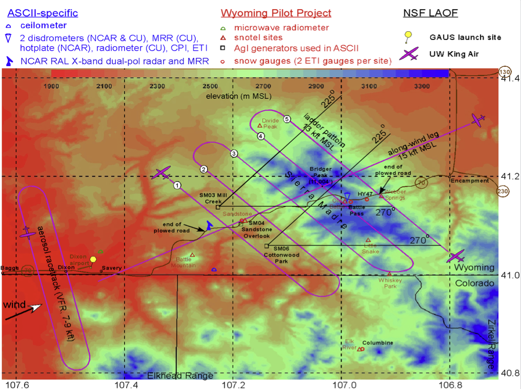 The AgI Seeding Cloud Impact Investigation (ASCII) field campaign is designed within the context of the Wyoming Weather Modification Pilot Project (WWMPP). ASCII will target the Sierra Madre, a NW-SE oriented continental divide mountain range in southern Wyoming. ASCII focuses on studying the cloud microphysical effect of glaciogenic seeding using 3 AgI generators in the Sierra Madre. ASCII will target the Sierra Madre under low-level flow from 225-270°, which provides a longer, rather unobstructed upwind fetch and a higher climatological probability of being able to sample enough “good” cases.<<click here>>.
_______________________________________________________________________________________________________________________________________
Testing remote sensing instruments for wind farm applications
 When monitoring winds and atmospheric stability for wind energy applications, remote sensing instruments present some advantages to in-situ instrumentation such as larger vertical extent, in some cases easy installation and maintenance, measurements of vertical humidity profiles throughout the boundary layer, and no restrictions on prevailing wind directions. We compare remote sensing devices, Windcube lidar and microwave radiometer, to meteorological in-situ tower measurements (NWTC M2 tower) to demonstrate the accuracy of these measurements and to assess the utility of the remote sensing instruments in overcoming tower limitations. .<<click here>>.
_______________________________________________________________________________________________________________________________________
ATOC/CU participation in VORTEX2 has been funded
 NSF-PDM is recommending support for the proposal on “Analysis and observations of particle size distribution in supercell thunderstorms”. The goal is to i) deploy mobile disdrometers within supercell thunderstorms during VORTEX2 in 2010, ii) conduct a comprehensive analysis to determine microphysical characteristics in thunderstorms by combining disdrometer and high-resolution polarimetric Doppler radar observations. Visit the VORTEX2 blog and the research page <<click here>>.
_______________________________________________________________________________________________________________________________________
NSF grant received for precipitation climatology in the Alps
 A 10-yr (1999-2009) climatology of precipitation will be developed based on high-quality radar measurements over an area within the European Alps. We propose to i) analyze the characteristics and four-dimensional structure of precipitation, ii) determine the role of synoptic-scale atmospheric circulation and upstream conditions on various time and space scales. For more information <<click here>>.
_______________________________________________________________________________________________________________________________________
ATOC/CU leading role in preparing the U.S. HyMeX participation
 The upcoming field campaign of the international program HyMeX (Hydrological cycle in the Mediterranean EXperiment; http://www.hymex.org/) in the fall of 2012 will attempt to obtain information on the most extensive-to-date range of processes contributing to heavy precipitation events (HPEs) over the orography of the northwestern Mediterranean Sea Basin. The U.S. HyMeX participation consists of over 15 scientists from various research centers and. Major NSF research facilities are requested (e.g., the NRL-P3 ELDORA, mobile polarimetric radars) in order to address the U.S. research objectives. For more information <<<click here>>>.
_______________________________________________________________________________________________________________________________________
Installing rain instruments in the skywatch lab almost completed
 The installation of a laboratory to measure some fundamental parameters for understanding radiative processes in the Earth’s atmosphere and to measure key elements of the hydrological cycle has been completed. The instruments and the data acquired will be applied to undergraduate curricula in ATOC. Please visit the Skywatch Laboratory and learn more about the instruments (e.g., Disdrometer).