A 10-yr climatology (1999-2009) on 4-dimensional precipitation characteristics using weather radar observations in the European Alps
Rudolph, J. V., K. Friedrich, U. Germann, 2010: Relationship between radar-estimated precipitation and synoptic weather pattens in the European Alps. submitted to J. Appl. Meteor.
Rudolph, J., K. Friedrich, and U. Germann 2010: The relationship between synoptic weather patterns and an operatinal radar-based precipitationclimatology for the European Alps (2000-2008). Conf. on Mountain Meteorology, Americ. Meteorol. Soc., August 2010, Lake Tahoe, USA.
Rudolph, J., K. Friedrich, and U. Germann 2010: Relationship between radar-estimated precipitation and synoptic weather patterns in the European Alps. 6th European Conference on Radar in Meteorology and Hydrology, September 2010, Sibiu, Romania.
Rudolph, J., K. Friedrich, and U. Germann, 2009: A 10 year radar-based precipitation climatology for the European Alps. Atmospheric and Oceanic Sciences Student Poster Conference, October 2008, Boulder, Colorado, USA.
Rudolph, J., K. Friedrich, and U. Germann 2009: A 10 year radar-based precipitation climatology for the European Alps. Conf. on Mesoscale Meteorology, Americ. Meteorol. Soc., August 2009, Salt Lake City, USA.
Mountains have a profound influence on our weather and hence climate. They act as a natural barrier on which weather systems can be deflected, modified, intensified, and newly build. Characterizing and quantifying precipitation in mountain regions is essential for better understanding of the processes that modulate precipitation intensity, distribution, and type in order to better distinguish between natural and climate change related variations. The knowledge about precipitation variability and the linkage to atmospheric circulation sets the basis for assessing the impact of climate change on precipitation in mountains and validating regional and global climate models.

This research focuses on developing a 10-yr (1999-2009) climatology of moderate and heavy precipitation based on high-quality radar measurements over an area within the European Alps of 600 x 500 x 20 km3 every 5 minutes with special resolution of 1 km. Through the use of four-dimensional radar reflectivity and Doppler velocity, we propose to i) analyze the characteristics and four-dimensional structure of precipitation as well as determine time-space variations of precipitation within five regions with highly differentiated climate conditions, ii) determine the role of synoptic-scale atmospheric circulation and upstream conditions on the precipitation characteristics, and iii) determine seasonal and annual variability of precipitation characteristics, atmospheric circulation, and upstream conditions.


In the first part the relationship between synoptic scale flow and mesoscale precipitation
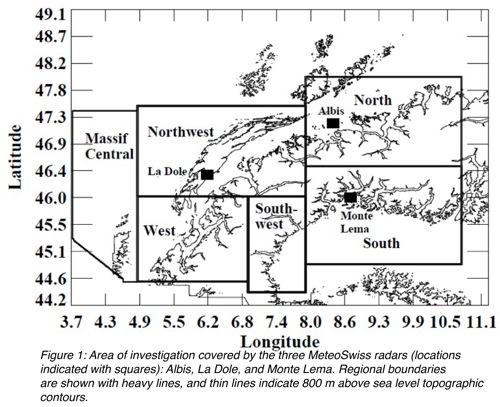
patterns over complex alpine terrain is studied. The analysis divides the Alps into six regions (each approximately 200 x 200 km2 in size), one on the northern, two each on the western and southern
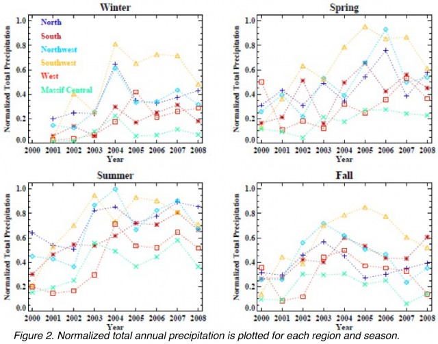
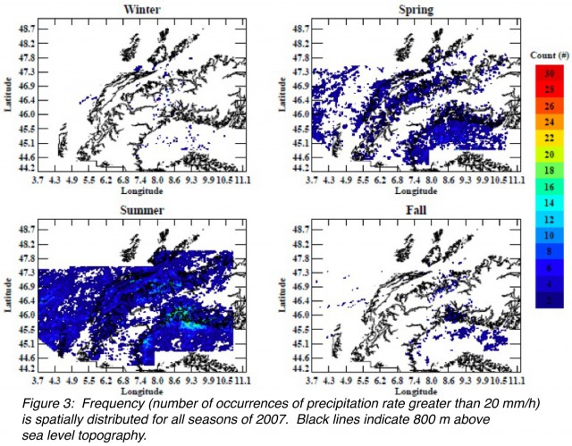
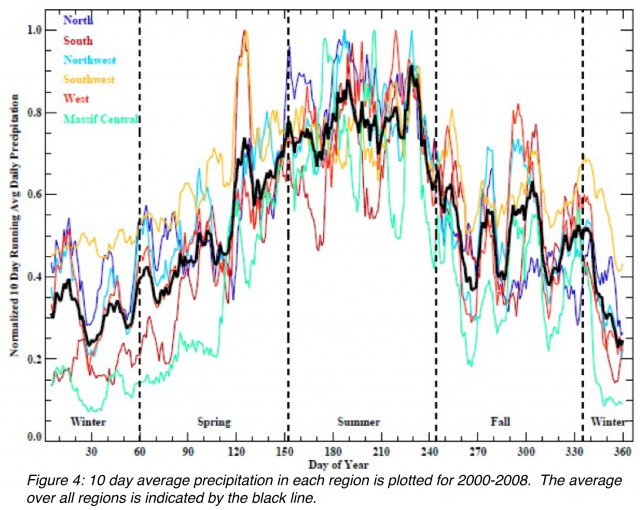
side of the Alps, and one in the Massif Central, representing various orographic aspects and localized climates within the radar coverage area (Fig. 1). For each region, estimated rainfall rate derived from radar data is analyzed on a seasonal basis for total daily precipitation and frequency of high precipitation rate events (Fig. 2). The summer season has the highest total daily precipitation for all regions in the study with median values of daily precipitation in winter less than half of median daily precipitation for summer (Figs. 3 and 4). Summer also has the strongest trend over all regions towards increasing total precipitation. No regional trends toward decreasing precipitation are found in any season. The fall season has the fewest regional trends in precipitation, except for the area south of the Alps where precipitation increases. High precipitation rate events occur most frequently in the summer, and the south and northwest Alpine regions have the greatest frequency of summertime high precipitation rate events. In all regions high rainfall rate events during summer qualitatively appear to have increased for 2003-2008 as compared to 2000-2002.

