Convection Initiation

Convection initiation along boundary-layer convergence zones

Boundary-layer convergence zones (boundaries) have long been known to be key factors in convection initiation and evolution. An examination of the literature suggests that boundaries such as cold fronts, gust fronts, sea-breeze fronts and drylines have received the largest amount of attention in terms of documenting their kinematic and moisture characteristics for convective weather forecasting applications.

Multiple-Doppler radar and rawinsonde data are used to examine misocyclone characteristics along gust fronts observed during the Convection and Precipitation/Electrification (CaPE) project in Florida. The objective of this study is to investigate the observational representativeness of previous numerical simulations of misocyclones by employing a consistent analysis strategy to 11 gust fronts observed in the same region. The investigation focuses on the intensity range of misocyclones and their organization along gust fronts; the relationship between misocyclone intensity and horizontal wind shear, vertical wind shear, and static stability; and the relationship between misocyclones and convection initiation. Organized misocyclone patterns were only found along small segments of gust fronts. Within those segments misocyclones were spaced between 3 and 7 km. Results show that the intensity of misocyclones was most closely related to the strength of horizontal wind shear across the gust front. The relationship between misocyclone intensity and vertical wind shear and static stability was not as clear. Although convection was initiated along the gust front in 7 of the 11 cases, those regions were not collocated with or in close proximity to misocyclones. For more information see Friedrich et a. 2005.

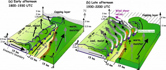
Figure 1: Horizontal cross sections of multiple-Doppler-derived data at 312 m MSL for (a), (b) 2129, (c), (d) 2144, and (e), (f) 2159 UTC on 2 Aug. (left) Horizontal winds (arrows) are overlaid on gray-shaded reflectivity (scale on the right), while (right) positive vertical vorticity (black contours) is overlaid on gray-shaded convergence (scale on the right). The location of a misocyclone first observed at 2129 UTC is indicated by a square [(b), (c), (e)], while the location of a misocyclone first observed at 2144 UTC is indicated by a circle [(d), (e)]. The location of the leading edge of the gust front is indicated at 2129 UTC as a dashed line, at 2144 UTC as a dashed–dotted line, and at 2159 UTC as a solid line, respectively.(Friedrich et al. 2005).

In the context of convection initiation we investigated the kinematic and thermodynamic structures of a nonprecipitating cold front (Fig. 2) observed in west-central Kansas on 10 June 2002 during the International H2O project with dropsondes and airborne instrumentation that include Doppler radars, a differential absorption liar, and in-situ sensors. The study revealed strong wind shear instabilities along the cold front leading edge and on top of the cold frontal flow which can be hypothesized to have a major impact on cloud formation (Fig. 2). The applicability of gravity current theory to the cold front was studied. There was evidence of certain gravity current characteristics, such as Froude numbers between 0.7 and 1.4, a pronounced feeder flow toward the leading edge, and a rotor circulation. Other characteristics, such as a sharp change in pressure and lobe and cleft structures, remain uncertain due to the temporally and spatially variable nature of the
phenomenon and the coarse resolution of the measurements. Addionally, an organized pattern of misocyclones and enhanced updrafts with a spacing of ~5–8 km were observed at the cold front leading edge. At the same time vortex lines manifested as horizontal vorticity maxima were observed within the cold air oriented perpendicular to the cold front leading edge and on top of the vertical wind shear layer. The analysis suggests that inflection point instability was the dominant mechanism for their development. Low Richardson number (0.3–0.4), short lifetime (<2 h), horizontal wavelength of 3–6 km, and collocation with strong horizontal and vertical wind shear are characteristics that support the hypothesis that these instabilities were Kelvin–Helmholtz waves. Towering cumulus developed along the cold front forming a convective cell close to the intersection of the cold front, dryline, and reflectivity thin line.

Fig. 2: Schematic diagram combining the results of this study with those achieved in Part I. The location of the surface cold front is shown as a blue line with alternating filled triangle symbols; the dryline is marked as a red line with semicircles attached; and the reflectivity thin line as a dashed red line. The kinematic boundary, defined as the zero across-front wind speed, is highlighted in gray. Wind vectors are indicated by black, solid arrows; magnitude of the wind vector is related to its thickness; dashed, gray lines indicate surface winds. Green shading is related to the moisture content; darker colors are related to higher moisture values. Areas of enhanced positive vertical vorticity are marked as purple circles with unidirectional arrow in (b); sizes of vertical vorticity symbols are scaled to their intensity. Updraft maxima are depicted by orange arrows; length is related to magnitude. Gray-shaded lines in (b) indicate schematically the location of vortex lines. More dense hatching for the capping layer corresponds to stronger stability. (Friedrich et al. 2008b)

Convection initiation in mountains

The relationships between pre-convective conditions in the atmosphere and the actual occurrence of convective initiation in the European Alps have been investigated. The European Alps region is a complex region that is affected by its mountains. Wind speed and flows are modified by terrain, latent heating, mesoscale effects and Coriolis force and is therefore a complicated area for forecasting. The investigation of CI that produces big amounts of precipitation and affects its surroundings is therefore a challenge to be investigated.

Figure 3: Localizations of Convective Initiation is plotted for the SW-flow. Initiation occurs in a lot of sub-regions. The intensity varies from low (orange) to high (red) CI occurrence in parts of the Southern Alps (Italy, Switzerland), the Black Forrest (Germany) and the southern part of the Jura (Switzerland).

Three different datasets where used to identify these relationship; surface observation analysis maps, upper-air sounding data and a radar data set provided by the Swiss Weather Service. The radar data were furthermore processed by the NCAR’s TITAN algorithm to extract storm specific parameters. A framework was set up to collect, analyze and compare the different datasets and asses the output data for the European Alps which was divided into nine different sub-regions. Outputs were collected for every sub-region and corresponding wind regime at the time of CI-occurrence. A first attempt to show the potential of the framework was made for May 2007 in which several CI-occurrences were present. Expected outcomes based on previous research were not found, although this was no surprise based on the amount of cases that were investigated. Nevertheless an overview of the locations of CI could be created and gave a first grasp of the localization of CI depending on the wind regime in the nine different regions (Fig. 3).

References

Friedrich, K., D. E. Kingsmill, C. Flamant, H. V. Murphey, and R. M. Wakimoto, 2008b: Kinematic and moisture characteristics of a nonprecipitating cold front observed during IHOP. Part II: Along-front structures. Mon. Wea. Rev., 136, 3796-3821..

Friedrich, K., D. E. Kingsmill, C. Flamant, H. V. Murphey, and R. M. Wakimoto, 2008a: Kinematic and moisture characteristics of a nonprecipitating cold front observed during IHOP. Part I: Across-front structures. Mon. Wea. Rev., 136, 147-172.

Friedrich, K., D. E. Kingsmill, and C. R. Young, 2005: Misocyclone characteristics along Florida gust fronts during CaPE. Mon. Wea. Rev., 133, 3345-3367.

  Friedrich, K., D. E. Kingsmill, and C. Young: Convection initiation and misocyclone development: I there a link? 22nd Conf. on Severe Local Storms, October 2004, Hyannis, MA, USA.